2nd study trip of the Institute for Historical Studies at the Piave and Gorizia from 14 to 19 October 2018
Day 1 – The Grenadier
He stands proudly and imperturbably, his head eagerly directed towards the west, in the direction of the oncoming enemy. He is prepared, has seized his armament, shouldered the equipment and applied the prescribed adjustment. The order will send him either to Malborget Fortress or to the Predil Pass. There he will try to stop the advance of the enemy troops – the best and most feared of that time. In this May of the year 1809, however, he and many of his comrades, heroic and with great bravery in the defense of the Fatherland against the overpowering enemy, will lose their lives or be taken prisoner. Later generations will put him on a pedestal (1909) and in books the scene of his heroic defensive battles, as the “Thermopylae of Austria [1]” characterize. Over the years, he has applied patina and eluded the history and growth of vegetation, people’s perceptions and perceptions. Finally, the forest around him was thinned, so that today he can again direct his view unhindered in the valley at his feet and in the direction of the former approaching enemy.
Immediately after the border, almost at the Tarvis motorway exit stands the monument of the imperial Austrian grenadier in memory of the battles in May 1809 against Napoleon’s troops. Even this first destination of our trip turned out to be a spectacular climax, because when you stand in front of the monument, you are truly impressed by its size and imposance. For a long time, neither the monument itself nor its surroundings could be seen as the area was surrounded by dense forest. Today, there is again a beautiful view and the historically interested visitor it is not difficult, at the foot of the overpowering warrior pulled into the spell of those times, the battles and the tactical conditions of Seinerzeit trace.
After this auspicious start of the 2nd Study Tour of the Institute for Historical Studies (IFHS), we aimed, according to the motto of the first travel section “In the footsteps of the FML Urbanski”, towards our destination San Dona di Piave. The trip was worked out and prepared jointly by the members of the IfHS and was excellently organized by our colleague Petra Stadler. Following the set goals, as well as the commemoration of the end of the First World War 100 years ago, we have designed the journey in addition to the aforementioned motto also from the point of view of the twelve Isonzo battles, so that the second part of us in the region led to Görz. The most important criterion for the trip, in addition to the visits and gaining new insights, the common experience and experience (in the best sense of the word) recognized, so we decided early in the planning to take a rental car, which offered us all. This decision proved to be the right one, because we were able to review the collected impressions, insights as well as the emotional aspects on the arrivals and departures together with our historical expertise.
So, after taking the auspicious start at the Imperial Grenadier and short stops in Malborget (Fort Hensel) and Pontafel (there was the imperial border with the still existing ancient landmarks – who knows today without googling what a myrmameter is? A myriameter is equivalent to 10,000 m ), the onward journey to San Dona was really historical and fun. Once there, however, finding the hotel proved to be tricky, because by a city festival in progress, there were roadblocks and a corresponding traffic on the alternative routes. After a short city tour in San Dona, we ended the evening with a good meal.
Day 2 – The traces of FML Urbanski
As of June 15, 1918, the k.u.k troops attempted to cross the Piave in their last attack, to tear up the Italians and thus end the war victoriously. FML Urbanski, the grandfather of our Honorary President, then commanded the 46th Rifle Division. In the course of the battle, it was actually succeeded parts of the o.-u.-Army to cross the Piave, briefly to form a bridgehead on the right bank and hold this a few days. During these dramatic days FML Urbanski arrived in San Dona and the Piave in order to find the most suitable areas of deployment during an exploratory mission for the imminent deployment of his 46th flight.
After breakfast and a brilliant lecture by our President that was full of all the facets of the high art of lecturing – the war situation on the Piave in general and the immediate situation in the San Dona area in particular – we were able to walk a short walk (our hotel was lying strategically ideal) reach the Piave and reminisce about events 100 years ago. Equipped with historical maps, we explored the shores of the Piave and were able to pinpoint the places that are important in the family history of our Honorary President, but also have a high significance for the tactical conditions of the events. We have all been impressed by the descriptions from the original records of the FML, which the latter expressly described in his war memoirs. Especially an event has occupied us for a long time. In his exploratory mission, FML Urbanski describes an attempt, always under enemy fire, to overrun the Piave under the railway bridge at San Dona, in order to suggest that his corps commander stop the battle due to probable failure. It was just at this railroad bridge that we too stood, 100 years later, and from the reports of the FML memoirs, with great reverence, we were able to immerse ourselves in the dramatic events of those days.
The Piave, which today is largely a tamed river, is in the section of San Dona fringed by wild scrub, partly dense shrubs and tall trees on both banks, so that a direct access or view of the river was only occasionally possible. At that point, we thought we could make out the terrain formations of former trenches and positions. To live in gratitude at a time when it is possible to walk in peaceful and undisturbed ways in many regions of Europe (where great human sacrifices were made one hundred years ago) has touched us deeply for the first time and should accompany us throughout the journey encounter again and again in many places.
After this first approach to the region and its history, we returned to the hotel and made our way to the planned afternoon stage. Along the Piave we drove upstream in the direction of Montello, the destination for the afternoon. In addition to the right bank of the Piave in the area of San Dona, the Montello was also a target that the O.-u. Troops were able to capture and hold for a few days in June 1918 (from 15 to 20 June 1918). Although our troops at that time managed to capture almost two thirds of the mountain, they could not be held in the Italian counterattack and you had to take the front back behind the Piave. Our aim was to get to know the conditions on site and, if necessary, to work out geographic and topographic factors influencing the course of the battle.
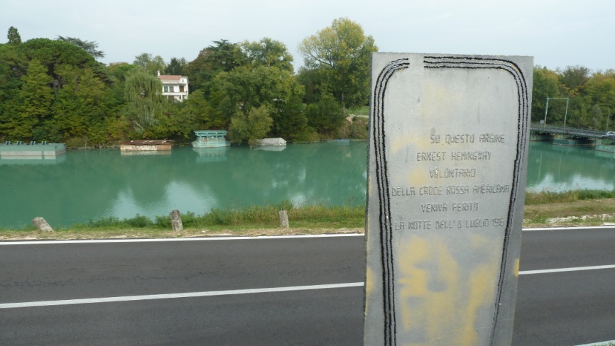
Contrary to expectations, however, we were confronted with an infrastructural problem during the journey, which at the beginning, as a nuisance in the further course of the journey (and travel) but as a source of unexpected cheerfulness, met completely unprepared: The car’s standard navigation device. Shortly after commissioning, we noticed his apparent misanthropy, had to perform several reboots due to malfunctions and finally lost the remainder of basic trust due to misdirected announcements. How good that there was still the navigation by means of two other mobile phones, which, however (due to different operating systems) also provided no synchronous information on the desired route. Highlight of the navigation madness (yes!) Was to drive the simultaneous request of two mobile phones and a car navigation system in three different directions. In the face of this “disorientation” of almost Babylonian dimensions, our president selflessly took the initiative and took the good old map as the last and most trusted quality assurance tool for navigation, so that now 5 people in the car, 4 with the navigation (incl. Drivers) were busy. After the successful elimination of the hindering circumstances, we were able to concentrate on the actual purpose of the journey and aimed at the goal. Again and again holding historical monuments or other memorable points, we have learned many impressions and interesting facts about the fighting on the Piave. Among other things, we reached the point on the river, at which time Ernest Hemingway, as a soldier of the Americas. Red Cross was injured, we stayed at the monument to the British 7th Infantry Division and set foot on one of the Piave Islands, was fought bitterly 100 years ago (this was easily possible, since the Piave at this point almost no Water led). When we finally reached the Montello, we realized that the ossuary erected on its summit did not open on Mondays for soldiers killed on the Piave! The area around the monument has been designated as a “Zona militare” and is fully fenced so that the visitor can not even access the grounds. The closed area did not keep us busy and we have, whether the many other, interesting and impressive memorials, fun started the return to San Dona.
Day 3 – The Grappa
Well rested, caressed and comprehensively pictured, today we have chosen to visit the Monte Grappa and the monument there for the Austro-Hungarian and Italian soldiers and, before that, a museum visit in Vittorio Veneto. The said museum houses a very versatile collection and has a pleasing scale, but the exhibits are – what turns out to be very anti-information – little or no signposted and described. One learns a lot about the Austrian occupation time in the region and above all about the big victory of the Italian army in October 1918 as well as their glorious army leaders. After an excellent cappuccino in the best café in the square, we left Vittorio Veneto behind us and drove on the famous Prosecco road to Monte Grappa. Along idyllic vineyards and picturesque villages, we sometimes enjoyed wonderful views and insights into this region. Over ever narrower serpentines, the road cascaded up the 1775m high Monte Grappa. Since our bus required the road to fill the entire width of the street and the bends could not be seen, a decrease in the intensity of the conversation had to be recorded in the car as the altitude rose. Before turning the horn, we climbed – on the right the gorge, on the left the mountain – after the next turn reversed, slowly the summit. Since – a leap of the car, followed by a short punch, already heard me all (as a driver) the S-word call shortly after, with “A Platter – right front!” To stop the car. The immediate inventory of the honorary president, as a passenger had this the shortest route, confirmed the first guess. A puncture at 1700m above sea level, far and wide no one – great! However, events of this kind promote the group dynamics and weld together. After a hardly noticeable irritation, we immediately searched the vehicle for jack and spare tire, found everything and started repairing the damage. Under difficult conditions (hillside, little space – I remember the big car and the narrow road) was the tire change relatively easily and after 15 minutes we could continue already.
Monte Grappa – a synonym of the First World War for both sides. Heroic, successful, blood-stained defending, and a magnificent, auspicious battle victory over there; unsuccessful, impotent, stained with great bloodcurser and the last great defeat hüben. The summit could never be taken by the O.U troops and always remained in Italian hands. Today, the Monte Grappa houses an extensive open-air museum with miles of hiking trails along the former front and on its summit a unique hero cemetery. This is a terrific example of the in this time (1920s and 1930s) in Italy usual construction. Pompous and monumental, the fallen are honored here and thought of their heroic courage. For the Austro-Hungarian fallen, a dignified memorial was built, which resembles that of the Italian in architecture and design, but is dimensioned much smaller. A long, narrow staircase leads from the parking lot to the central area of the sacred building and is impressed by its dimensions and unobstructed distant views in all directions. Unfortunately, the weather was cloudy that afternoon, so we could only vaguely perceive the environment in the distance. Nevertheless, the cloud cover with its scattered sunbeams and cool wind, in a strange way, corresponded to an inner expectation developed for such sites. Awe, silence and transience are the emotional mix of the building in the face of the building, the many thousands dead and the infinite mountains creates an atmosphere that culminates in a compassionate-liberating consolation, that the memory of the men driven to death is at least thought in dignity. There is no question about the dubious political epoch in Italy, in which many of these sites were conceived, planned and implemented, but: their care, their venerable and solemn handling of remembrance and remembrance, which extends to the present day, are worthy of all honor ! With the return trip, which was made on a different route and on which, with reaching a low three-digit sea level, the fun in the car has again begun, the eventful, long day has come to a satisfying end.
Day 4 – To the Isonzo
On this day we left the Piave and, following the second main focus of our journey, left for Gorizia. Before that, however, following the recommendation of our hotelier, we visited the local historical museum in San Dona. The staff welcomed us with great amazement and introduced them with the same enthusiasm in the way of the museum. Later, we felt that we were the first and only visitors for a long time. The museum spans an information arc from the ancient Romans to the modern age, developing the character of a local history museum, even though a room is dedicated to WWI.
Avoiding the highways, we have decided to use the former supply routes (today SS14) to the Piavefront to get a better idea of the long distances and other conditions that have demanded the Austro-Hungarian train and supplies a hundred years ago everything. Shortly before Cervignano, we then found the old landmark as the “milestone” of the day of arrival in Gorizia, marking the border between the monarchy and Italy. Immediately on the river Ausa is the obelisk running way mark. After a short break at this historic site, we continued our journey in a happy mood, always cheered up by erroneous announcements of the navigation device, and drove over Gradisca to Gorizia.
Day 5 – In the karst
We talked a lot about this in advance and in the program compilation. The author of these lines – who was already the only representative of the association – has often highlighted in dazzling colors the overwhelming and pompous nature of the memorial and also described its surroundings in glowing words. Redipuglia – the largest and most sublime monument of the Italian culture of adoration and remembrance of the First World War. 100,000 soldiers of the Italian 3rd Army are buried there, who have found in a monumental structure with 22 plateaus together with their army commander the final resting place. Well, when we reached the destination in the morning and all already spellbound fanned the monument, the almost impossible happened: Construction Site – No Access! The area was cordoned off large-scale, everywhere one could recognize brisk construction activity. Despite or because of the distance from the opposite parking lot, the size and dimension of the final resting place of so many fallen ones is overwhelming. Looking in the face of inevitability, we have quickly taken the disappointment away and turned towards the Colle Sant Elia before us, which houses the Parco della Rimembranza. On this hill, in addition to the heroic cemetery Redipuglia, a memorial was built and a homage was erected to the individual arms of the war.
Shadowed by a fragrant pine grove, one walks the small hill and passes by neat celebs of many arms, which are provided with poetic sayings and are equipped with their characteristic utensils. The plant is supplemented by all sorts of war equipment, mainly cannons and howitzers of different typologies. Austro-Hungarian models can also be found here. As the 12:00 o’clock bells ushered in the noon on this day and we from the distance a determined movement of movement of the Italian construction workers in the direction of the canteen, we thought very fast the plan to the heroic cemetery Redipuglia still pay a visit to whose now taking advantage of the orphaned situation during the lunch break to take a close look at the awesome site. As anticipated, the mountain side section of the heroic memorial was actually cleared and we were able to enter the facility for a few minutes, captivating us with its extraordinary aesthetics.
A few hundred meters further from Redipuglia, in Fogliano, lies the Austro-Hungarian military cemetery. On the way to the next stage, we stopped there and visited the final resting place of the Austro-Hungarian defenders. The war cemetery is in good condition and you will be informed at the entrance that Pope Francis has already paid a visit to this memorial. Many Hungarian soldiers are accommodated in this place, which in total houses the remains of 14,550 Austro-Hungarian soldiers. Strictly aligned and bedded in a luscious green, you will find on the gravestones so many names whose wearers counted only 18, 19 or 20 years. To be aware of this, deep consternation and thoughtful silence spread among us, which we all move back and forth in far greater age and peace.
After a pleasant lunch in Gradisca we reached Monte San Michele. This foremost peak of the Karst high plateau in the south of Gorizia marked in the first Isonzo battles the hotly contested cornerstone of the ö.-u defensive line. After the Italian declaration of war on 23.05.1915, for strategic reasons and in the face of Italian superiority, Austria-Hungary first erected the first line of defense on the high plateau of the Karst and expected the Italian assault waves to attack. Only in the fifth battle succeeded the Italian 3rd Army under enormous losses to take the Monte San Michele. The conquered positions of the Austrians were occupied and rebuilt for their own purposes. Today you will find on Monte San Michele (375m above sea level) a small museum and an impressive open-air museum that gives a good impression in the Italian Stellungsbau. Well-developed and easily accessible paths lead through the grounds and you get a magnificent view over the former battlefield in the karst and can see in good weather to the Adriatic Sea. An evening walk in Görz rounded off a remarkable day in style.
Day 6 – Monte San Gabriele
After the 6th Battle of Isonzo, when the Italians occupied Gorizia (before the Monte Sabotino on the right bank of the Isonzo was torn from the Austrian defenders), the small summit north of Gorizia became more and more the center of events that we wanted to climb that day. Slowly, the Italians fought in the course of 9 battles, but were repeatedly rejected by the Austrians. After the 10th battle, one stood in the immediate vicinity of Monte Santo and could look directly into the face of the mountain. The 11th now should bring the decision for the attackers. When the plateau of Bainsizza-Heiligengeist was conquered and the mountain was still held as the last cornerstone of the Austrian defense on the Isonzo front, Cadorna had everything to offer what the Italian assault power had to offer. In an incredible material and human battle, the mountain was stormed by a total of about 80,000 men, while shells of all caliber flew continuously to the defenders. 10,000 endings on both sides have fallen on its slopes. The Austrians held on and were able to hold the summit until last. The mountain of death – the Monte San Gabriele – remained in Austrian hands.
We had read a lot about this survey (646m above sea level), which we spent on the 6th day of travel as a destination. Along well-marked trails, past a memorial to the 20th Honved Infantry Division and former sanitary and supply caverns, we reached the summit after a good hour. Since the mountain is today completely forested, in contrast to the past, a viewing platform over the treetops was erected on its summit, which allowed us to maintain a fantastic panoramic view of the entire region during the Kaiser weather. Equipped with historical and up-to-date maps, we were able to trace the frontal course of the 10th and 11th Isonzo Battle from there, the peaks of Monte Sabotino, Monte Santo in front of us and Monte San Michele on the side. The high plateau of Bainsizza-Heiligengeist lay spread out in front of us and the valley to Cepovan, which marked the front line at the end of the 11th Battle of Isonzo, formed with its deeply carved valley bottom a striking, dark depression that stood out clearly visible from the gray-green wooded plateau. At our feet we could follow the Isonzo, whose turquoise-blue color shone up to us. For some time we stayed up there and let the impressions affect us, always aware of what horrible place this mountain had been 100 years ago. The way back we completed along the circular route and passed so well-developed Austrian positions. Even today you can see in the forest the paths, the combat coverages, MG positions, caverns, the first and the second line of defense. Unforgettable will remain for us all the fighting position that was created directly on the slope and gave us an impression of what it must have meant for the Italian soldiers to lead an attack at this point and on this mountain from the valley. We shuddered in the position of the Austrian defenders and the attacking understood that first the artillery preparation, partly with gas, then provided for the infantry attack. We went to the trenches, as far as they were accessible and tried to imagine how the soldiers after the alarm from the caverns and shelters ran and threw themselves to the Italians. MGs, hand grenades, rifles have struck down the abgehten, the mountain partly climbing the slope on all fours opponents. Unbelievable and a shake of the head made us feel, if you look at the local conditions today. Despite the nice weather, we thoughtfully went on the further round trip and are shaken up, but with much knowledge richer, returned to the car.
Now it was time to take care of the physical well-being, so we drove to Solkan, the district at the foot of Monte San Gabriele, where we refreshed our mind and body and recharged the “batteries”. The day ended with a visit to the old railway bridge and a nearby Austro-Hungarian military cemetery. The railway bridge was at the time of its establishment in 1908, the world’s longest stone arch bridge, was blown up in the course of the 6th Battle of Isonzo by the Austrians and after the war, first as a provisional, later then faithfully rebuilt by the Italians. Today, the area around the bridge is a popular meeting place, especially for the young people of the city. There is a climbing park on its pillars and in the Isonzo under the bridge a Übungsparkour was set up for whitewater paddling. The last event of the day was a visit to the Austro-Hungarian military cemetery not far from the bridge. Located behind the railway tracks and not labeled, only a few visitors find it, it forms among all the tombs visited a rather hidden example, although its location surrounded by the three mountains (Monte Sabotino, Monte Santo, Monte San Gabriele) and right on the river is very impressive. In the middle of the cemetery stands a stone pyramid with a simple inscription: “I had a comrade”.
Day 7 – drive home
The day of the trip home took us along the Isonzo, past all the battlefields to the north, where we reached Kobarid around lunchtime. As always, the visit to the local museum turned out to be a special event, because apart from the magnificent exhibition and the fantastic railing relief, which shows the war situation in the area Flitsch – Karfreit – Tolmein in an outstanding way, there is always something going on. So again. At the time of entry, we were informed that the Slovenian and Hungarian Prime Ministers had been announced for this day, and that we would have to follow the instructions of the security staff if necessary. Of course, this prospect did not detract from our thirst for knowledge, and we did not allow ourselves to be deterred by the actual arrival of the phalanx surrounding the two politicians from the exact study of the exhibited exhibits. This time there was no news in the bookshop, so we went on without the library, but with considerable knowledge gain. A final stop in Log pod Mangartum at the Kaiser-Josef-Hilfsstollen and at the military cemetery informed us on the one hand about the Austrian engineering achievements and on the other hand brought about the Bosnian troops and their fight and death for the empire.
Driving back over the Predilpass, we sat on the terrace at Lake Raibl again and enjoyed the lunch, before we, following the circuit at the old Grenadier in Tarvisio, again reached the highway and went to Vienna to attack the last stretch.
Conclusion and perspective
The second study trip of the Institute for Historical Studies will be remembered for a long time and we will preserve the experiences, insights and emotions and in the preparation of the next journey, which will lead us to the former war in the East, to Lviv and beyond, to flow into. We were able to deal directly with events of the war on the former southwest front, learned a lot about tactical, strategic and topographical contexts, we were able to immerse ourselves in landscapes and regions, we enjoyed the scent and culinary art of the South, and above all, We were able to gain a glimpse of what it must have meant to be a soldier in this war on Monte San Michele, Monte Grappa, Monte San Gabriele, and in so many other theaters of war, fighting daily for his life.
As I said, just a fraction of a hunch …
Author and photos: Rostek Marko, member of the board